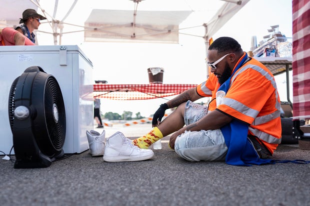
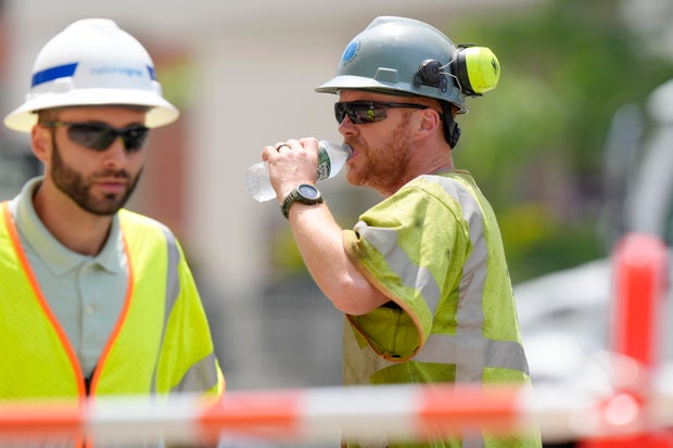
A relentless heat wave that baked more of the United States this past week is expected to continue and expand this weekend.
Millions of Americans – particularly those in the highly populated Interstate 95 corridor are under heat-related advisories or alerts as the squelching heat is expected to hit record-breaking temperatures in some areas. In some places, the humidity will bring the heat index values as high as the mid-100s.
Forecasters with the National Weather Service (NWS) said Saturday they expect the high temperatures to be in the mid-to-upper 90s from the central and southern Plains to the East Coast.
“These temperatures remain the most anomalous and dangerous for early summer over portions of the Midwest/Ohio Valley east to the Mid-Atlantic,” it said.
Carolyn Kaster / AP
Thennie Freeman, director of the Washington, D.C., Department of Parks and Recreation, told CBS News that they are asking people to be mindful of how hot and dangerous it can be and to avoid overheating by staying inside or going to cooling centers.
“Heat exhaustion is a real thing. And so we want our residents to be safe from extreme heat,” Freeman said. “Drink plenty of water, wear loose fit clothing, wear a hat, stay out. Avoid the heat in the sun during these peak hours as much as possible.”
There was no escaping the sun for New York City tourists waiting to see the Statue of Liberty Saturday.
“I’m switching out shirts every other hour,” Grant Leavitt of Arizona told CBS News.
Getty Images
New York City health officials said heat-related emergency room visits this week were 500% higher than the average day in June.
Even though temperatures in Washington, D.C., cracked 100 degrees Saturday, grill masters fired up their barbecues for a popular annual event.
And in the Midwest, humidity levels in the Ohio River Valley made it feel like triple digits, and some looked for relief on the river in Dublin, Ohio.
“Even anything remotely strenuous on days like this it’s pretty exhausting,” kayaker Chad Brennan told CBS News.
Relentless heat expands
Millions of residents across the country have had their lives disrupted by days of unusually high temperatures.
In Michigan, utility crews from several states were working feverishly Friday to restore power to thousands of suburban Detroit customers, two days after severe storms knocked out their power, leaving residents suffering amid a heat wave expected to linger through Saturday.
Steven Senne / AP
About 12,000 homes and businesses remained without power Friday afternoon in Oakland County, a suburban area north of Detroit hit hard by Wednesday night’s storms that cut power to about 75,000 homes and businesses at its peak, said Brian Calka, DTE Energy’s vice president of distribution operations.
Between 500 and 600 crew members from utilities in Ohio, Indiana and Illinois were working with about 1,000 DTE Energy utility workers and another 1,000 tree-trimming contractors to get the power back on amid the heat. Calka said the utility’s goal is to get the power back on for all its customers by late Friday or early Saturday.
Utility crews were working 16-hour shifts to get the power back on and they were urged to deal with the heat by taking more breaks because they are wearing jeans, long-sleeved shirts, rubber gloves and hardhats for their work, Calka said.
“They are working in very, very tough conditions,” he said.
In Idaho, officials said two people in their 60s have died of heat-related causes — the state’s first heat-related deaths of the year. Health officials did not release additional information about the victims Friday, including where they died.
This month’s sizzling daytime temperatures were 35 times more likely and 2.5 degrees F hotter (1.4 degrees C) because of the warming from the burning of coal, oil and natural gas — in other words, human-caused climate change. That is according to World Weather Attribution, a collection of scientists that run rapid climate attribution studies that have not been peer-reviewed.
Flash flooding concerns amid heat
The excessive heat wasn’t the only weather-related issue in some states.
“So we’re off the charts currently,” Washington University geophysics professor Dr. Michael Wysession told CBS News. “We now have a record 12 months straight of global temperature records. When the world gets warmer we increase our severe weather events. Interestingly, we actually get more flash floods.”
Widespread showers and thunderstorms that sparked flash flooding in parts of New England and the Great Lakes will continue on Saturday with “plentiful moisture” that will increase the chance for locally heavy downpours, the NWS said.
Several small-town tourist meccas in northern Minnesota continued to be inundated by floodwaters after a deluge of rain earlier this week, prompting the closure of major roads and leaving a costly trail of damage.
And in south-central Minnesota, copious rain has ended a three-year drought, but is flooding fields and killing crops.
“Instead of 10,000 lakes, Minnesota is, I don’t know, 150,000 lakes at this point,” farmer Owen Gohlke joked to CBS News.
To the west, several South Dakota campers who’d gathered to see a now-canceled race at Huset’s Speedway near Sioux Falls were rescued by boat Friday, Minnehaha County Chief Deputy Jeff Gromer said. No one was injured.
The governor of Iowa sent helicopters to a small town to evacuate people from flooded homes Saturday.
Sirens blared at 2 a.m. in Rock Valley, Iowa, population 4,200, where people in hundreds of homes were told to get out as the town could no longer take the rain that has slammed the region. The city lacked running water because wells were unusable.
“We’ve got National Guard helicopters coming in where people are on their roofs — literally on their roofs or the second floor because their first floor is completely flooded,” Mayor Kevin Van Otterloo said.
“We’ve had so much rain here,” he said. “We had four inches last night in an hour and a half time. Our ground just cannot take anymore.”
Sioux County Sheriff via AP
Gov. Kim Reynolds ordered a disaster proclamation for Sioux County, which includes Rock Valley. Drone video posted by the local sheriff showed no streets, just roofs and the tops of trees above water.
NWS forecasters said the highest chance for potentially significant heavy rainfall will be along the Upper Great Lakes and Upper Mississippi Valley and in parts of southern New England.
Meanwhile, temperatures in the western and central U.S. will rise as well. In much of the interior Pacific Northwest, Great Basin and California, the temperatures will be in the mid-90s to low 100s on Saturday.
“Monsoon-like conditions” prompt evacuations
In New Mexico and Nevada, the temperatures will still be hot but “monsoon-like conditions” will remain over the region. Highs over the weekend will be in the mid- to upper 100s with scattered showers and storms bringing the threat for locally heavy downpours.
The heavy rain and flash flood warnings prompted New Mexico officials to order some mandatory evacuations, with shelters set up for displaced residents.
Up to 2 inches (5 centimeters) of rain had fallen by late Friday with additional rainfall up to 1.5 inches (3.8 centimeters) expected overnight, the weather service said.
There was flash flooding with multiple road closures on the north and west sides of Las Vegas, the weather service said.


